|
Directions
The UNH campus map may be found at: http://www.unh.edu/transportation/visitor/map.pdf and the field facility at the West End Parking lot is the blue-colored lot on the upper left hand corner of the map.
Visitor parking is not permitted at Gregg Hall. You will need to go to the UNH Visitor Center at 295 Mast Road for parking information and permits. From the Visitor Center, it is a very short walk from there to Gregg Hall, about 5 minutes. Directions to the Visitor Center, from Visitor Center to Gregg Hall, and a walking map are below.
DIRECTIONS TO UNH VISITOR CENTER & PARKING
From Boston, MA
Take I-95 North from Boston t o Exit 4 (Left hand exit, says to: NH Lakes and Mountains Region; routes 4 and 16). Continue to Exit 6W (approx 2 miles) and follow Route 4 West (approx 10 miles). Go beyond the UNH/Durham Route 108 exit. Take the exit for Route 155A. At the bottom of the exit ramp take a left towards Durham. Take the second left on to Loop Road (approx 1/2 – 3/4 mile from the exit ramp). At the stop sign at the far end of Loop Road, turn right. The Visitor Information Center and Visitor Parking are on the left.
From Northern NH
Option 1: Take Route 93 South to Route 393 East to Route 202 & 4 East all the Way to Durham. Take the exit for Route 155A (2nd exit after the Lee Traffic Circle). Bear right at the bottom of the ramp. Take the second left on to Loop Road (approx 1/2 – 3/4 mile from the exit ramp). At the stop sign at the far end of Loop Road, turn right. The Visitor Information Center and Visitor Parking are on the left.
Option 2: Take Route 16 South to Route 155. Follow Route 155 West for approximately 5 miles. Take a left on to Madbury Road (just past the Elliott Rose Greenhouses which will be on the left after crossing the “bridge” over the RR tracks) to the traffic lights. At the traffic lights take a right on to Route 4 West. Follow Route 4 to the exit for Route 155A. At the bottom of the exit ramp take a left towards Durham. Take the second left on to Loop Road (approx 1/2 – 3/4 mile from the exit ramp). At the stop sign at the far end of Loop Road, turn right. The Visitor Information Center and Visitor Parking are on the left.
Option 3: Take Route 16 South to Route 125 South. Follow Route 125 until you reach a traffic circle (approx. 10-12 miles). Go 3/4 way around the circle and take Route 4 East. Take the exit for Route 155A (2nd exit from the circle – 2 miles). Bear right at the end of the ramp. Take the second left on to Loop Road (approx 1/2 – 3/4 mile from the exit ramp). At the stop sign at the far end of Loop Road, turn right. The Visitor Information Center and Visitor Parking are on the left.
From Western NH
Option 1: Take route 101 East to Exit 7 (Route 125). Take route 125 North to the Lee traffic circle (approx. 8 miles). Go 1/4 way around the circle and take route 4 East. Take the 2nd exit (2 miles). It is marked UNH/Durham. At the bottom of the ramp bear right.
Take the second left on to Loop Road (approx 1/2 – 3/4 mile from the exit ramp). At the stop sign at the far end of Loop Road, turn right. The Visitor Information Center and Visitor Parking are on the left.
Option 2: Take route 202 east to Route 89 South. At the end of Route 89 take route 93 North to Route 393 (towards Portsmouth). Follow Route 393 to the end where it merges with route 4 & 202 East. Follow Route 202/4, you will pass through 2 traffic circles (one in Epsom & one in Lee) – go 1/2 way around both of them staying on route 202 & 4 East. After the second traffic circle take the second exit (marked for UNH & Durham – 2 miles). At the bottom of the ramp bear right. Take the second left on to Loop Road (approx 1/2 – 3/4 mile from the exit ramp). At the stop sign at the far end of Loop Road, turn right. The Visitor Information Center and Visitor Parking are on the left.
From Maine
Take Route 95 south to Route 16 North (Spaulding Turnpike). Follow Route 16 North to exit 6W (Route 4 West). Go beyond the UNH/Durham Route 108 exit. Take the exit for Route 155A. At the bottom of the exit ramp take a left towards Durham. Take the second left on to Loop Road (approx. 1/2 – 3/4 mile from the exit ramp). At the stop sign at the far end of Loop Road, turn right. The Visitor Information Center and Visitor Parking are on the left.
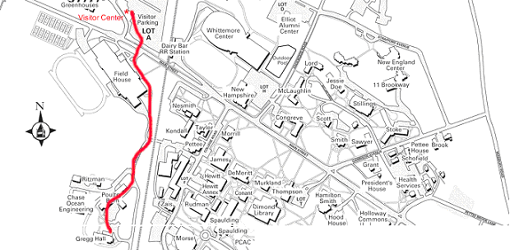
WALKING DIRECTIONS TO GREGG HALL FROM VISITORS LOT/A LOT
Gregg Hall is only a short walk from the Visitor’s Center. Walk though A Lot towards the front of the Lot (towards Main St.). Walk though the pedestrian tunnel (which brings you right up in front of the Field House), or take steps up to Main St. If you have taken the steps you’ll need to cross to the other side of street, in front of the Field House.
Walk across in front of the Field House, around to the left side. Follow the path down to Colovos Road, continue straight ahead, take 2nd right into Gregg Hall Lot.
|