


UNH, Partners in Northeast Share $1.4M Flood Planning Grant
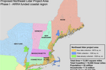
Map courtesy of Maine Office of GIS. Click image for larger version.
DURHAM, N.H. - The University of New Hampshire's GRANIT program is part of a diverse consortium of stakeholders from New England and New York that has been awarded $1.4 million in United States Geological Survey funding to collect high resolution light detection and ranging (LIDAR) topographic data for coastal areas in the region.
The funds, which come from the American Recovery and Reinvestment Act of 2009, will be used to collect data over an area encompassing approximately 9,000 square miles, extending from New York City to Eastport, Maine. The effort comprises the first phase of a long-range plan to acquire data across the entire seven-state region.
Members of the consortium include representatives of state government, universities, local government, Indian tribes, and nonprofit organizations. The GRANIT program (www.granit.unh.edu) within UNH's Institute for the Study of Earth, Oceans, and Space is representing New Hampshire's interest in the collaborative effort. NH GRANIT serves as the state's Geographic Information System (GIS) clearinghouse.
LiDAR systems use laser pulses from airborne systems to measure elevations of the Earth's surface, vegetation, and developed environments. The technology offers a way of obtaining very precise, accurate, and cost-effective elevation data seamlessly over large geographic areas.
Consortium members are linked by common geography, history, climate, and culture, and share a long, well-developed coastal community. Most of the region is low-elevation and susceptible to coastal flooding and sea level rise, which can have devastating effects on the larger cities as well as the many smaller coastal fishing or tourist communities in the region.
Elevation data collected through this funding will allow the states to enhance local and regional flood planning and mitigation activities. In addition, the detailed elevation data will support a host of other uses, including emergency preparedness, transportation planning, watershed protection, aerial photo processing, land cover mapping, shoreline change modeling, air mass modeling, wireless signal propagation.
Data will be collected from the fall of 2010 through spring 2011. Once processed it will reside at GRANIT as well as at the USGS and will be available to the public.
The University of New Hampshire, founded in 1866, is a world-class public research university with the feel of a New England liberal arts college. A land, sea, and space-grant university, UNH is the state's flagship public institution, enrolling 12,200 undergraduate and 2,200 graduate students.
-30-
Image available to download: http://www.eos.unh.edu/newsimage/arra_lg.jpg.
Map courtesy of Maine Office of GIS
Reporters and editors: Fay Rubin is available to comment at mailto:fay.rubin@unh.edu"
Latest News
-
July 2, 2024
-
June 18, 2024
-
June 18, 2024
-
May 17, 2024
-
May 14, 2024