


UNH Researchers Find Better Way to Delineate Tree Crowns Using Aerial Imagery
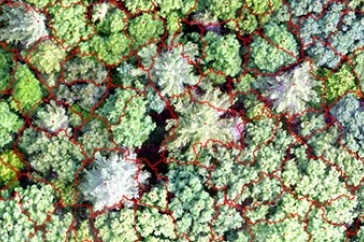
Experiment station researchers have found that the spectral (wavelengths of light) information from natural color imagery more accurately identifies individual tree crowns—the branches and leaves/needles extending from the trunk—than the traditional canopy height model when used in conjunction with unmanned aerial systems.
DURHAM, N.H.—In a new study, University of New Hampshire researchers have concluded that when assessing forest imagery collected by unmanned aerial systems, an alternative method of delineating individual forest tree crowns within those images is more accurate than the most commonly used method, the canopy height model. The research is important to New Hampshire landowners and forest managers as mapping and monitoring forests is a key component of managing natural resources. According to the North East State Foresters Association, the annual value of sales of New Hampshire’s forest products industry totals nearly $1.4 billion.
Researchers at the New Hampshire Agricultural Experiment Station have found that the spectral (wavelengths of light) information from natural color imagery more accurately identifies individual tree crowns—the branches and leaves/needles extending from the trunk—than the traditional canopy height model when used in conjunction with unmanned aerial systems.
Additionally, the results for a mixed forest—one not dominated by either deciduous or coniferous trees—were not much different than either a conifer or deciduous forest alone. Most previous work in this area was done on conifer forests because the crown shape is easier to detect. However, much of the forested land area in New England and other parts of the United States contains both types of trees.
Improved accuracy in identifying and measuring tree crown size and shape can reveal much about the ecology and competition in the forest, according to Russ Congalton, professor of natural resources and the environment. Individual tree crowns also are an essential data product for precision forestry.
“Improvement in geospatial technologies, including the collection of remotely sensed imagery, has substantially increased our ability to generate effective and efficient information about our forests,” said Congalton. “Recently, the development of unmanned aerial systems has allowed for very cost-effective and high-resolution imagery. This imagery has the potential to provide information at a level of detail beyond what has historically been possible.”
This research is published in the journal Forests. Collaborators include postdoctoral research associate Jianyu Gu, and doctoral student Heather Grybas.
This material is based upon work supported by the NH Agricultural Experiment Station, through joint funding of the National Institute of Food and Agriculture, U.S. Department of Agriculture, under award number 1015520, and the state of New Hampshire.
Founded in 1887, the NH Agricultural Experiment Station at the UNH College of Life Sciences and Agriculture is UNH’s original research center and an elemental component of New Hampshire's land-grant university heritage and mission.
The University of New Hampshire inspires innovation and transforms lives in our state, nation and world. More than 16,000 students from all 50 states and 71 countries engage with an award-winning faculty in top-ranked programs in business, engineering, law, health and human services, liberal arts and the sciences across more than 200 programs of study. As one of the nation’s highest-performing research universities, UNH partners with NASA, NOAA, NSF and NIH, and receives more than $110 million in competitive external funding every year to further explore and define the frontiers of land, sea and space.
DOWNLOAD AVAILABLE
https://colsa.unh.edu/nhaes/sites/default/files/media/images/naturalcolor.jpg
Experiment station researchers have found that the spectral (wavelengths of light) information from natural color imagery more accurately identifies individual tree crowns—the branches and leaves/needles extending from the trunk—than the traditional canopy height model when used in conjunction with unmanned aerial systems.
-
Media Contact
Lori Tyler Gula, PhD | NH Agricultural Experiment Station | lori.gula@unh.edu | 603-862-1452
Latest News
-
June 18, 2024
-
June 18, 2024
-
May 17, 2024
-
May 14, 2024
-
May 7, 2024