


UNH Updates Coastal Flood Hazard Maps for NH Communities
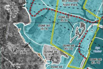
Extract from draft, updated floodplain map in Rye Harbor, NH. Courtesy of NH GRANIT.
DURHAM, N.H. -- Based on work conducted by the University of New Hampshire, coastal New Hampshire communities in Strafford and Rockingham counties have received updated preliminary flood hazard maps as part of the Federal Emergency Management Agency's (FEMA) nationwide program to update coastal flood hazard maps.
The release of the maps is the result of a long-term study led by the New Hampshire Geographically Referenced Analysis and Information Transfer System (NH GRANIT) at the UNH Institute for the Study of Earth, Oceans, and Space (EOS). The study, begun in 2010, involved extensive collaboration with state and local partners and will culminate once the maps and associated reports complete the scheduled public review, appeal, and implementation periods in late 2015.
Community officials and residents in the 17 coastal communities are encouraged to review the new preliminary flood maps to become familiar with the flood risks and see whether their flood zone has changed around their property. Every community in the study area has received both a paper copy and a digital copy of the new maps to share with their residents for review before they become finalized. The maps can also be viewed at each community's municipal office or online at the FEMA Map Service Center found at www.fema.gov/preliminaryfloodhazarddata.
"The current effective maps were developed in the 1970s and 80s, and are outdated and based on old technology," says Fay Rubin, director of GRANIT, which created the new maps based on state-of-the-art techniques. "Now, there are new modeling technologies that are significantly improving the mapping of the coastal zone, and for the entire study area, the 17 coastal communities, we now have topographic data that provides for a very accurate representation of the landscape. This leads to improved mapping of flood hazard areas, and therefore a better understanding of risk."
Flood hazard maps, also known as Flood Insurance Rate Maps, indicate whether properties are in areas of high, moderate, or low flood risk. In reviewing the new Strafford and Rockingham County maps, many property owners may find that their risk of flooding is higher or lower than they thought. If the risk level for a property changes, so may the requirement to carry flood insurance. Homeowners are encouraged to contact their local floodplain manager for more information.
NH GRANIT is a cooperative project to create, maintain, and make available a statewide geographic database serving the information needs of state, regional, and local decision-makers. A collaborative effort between UNH and the NH Office of Energy and Planning, the core GRANIT System is housed at the Earth Systems Research Center within EOS. It includes a geographic database, hardware and software to build, manage, and access the database, and a staff of experts knowledgeable in geographic information systems, image processing, and computer analysis.
For more information, visit http://www.granit.unh.edu.
The University of New Hampshire, founded in 1866, is a world-class public research university with the feel of a New England liberal arts college. A land, sea, and space-grant university, UNH is the state's flagship public institution, enrolling 12,300 undergraduate and 2,200 graduate students.
Image to download: http://www.eos.unh.edu/newsimage/GRANIT_maps_lg.jpg
Caption: Extract from draft, updated floodplain map in Rye Harbor, NH. Courtesy of NH GRANIT.
-30-
Latest News
-
September 15, 2025
-
August 21, 2025
-
August 12, 2025
-
August 5, 2025
-
June 25, 2025