


UNH Grad Certificate Course in Geospatial Science Offered July 15-26
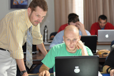
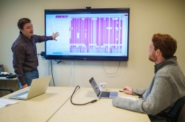
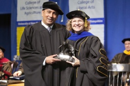
Credit: Michael Routhier (left) is the certificate program coordinator and instructor for the Applied GIS for Research class. Photo by Katelyn Dolan, UNH-EOS.
DURHAM, N.H. -- A two-week course in the University of New Hampshire's Geospatial Science Graduate Certificate program is being offered beginning Monday, July 15, 2013, on the UNH Durham campus.
The four-credit Applied GIS for Research class is open to anyone holding an undergraduate level degree, and can be taken as one of the five requirements for completion of the certificate program or as an independent class.
The course goal is to provide students with a solid foundation in the use of the concepts and applied techniques of GIS (Geographic Information System) as a tool to solve real-world problems across multiple disciplines. The course is part of the university's new, multidisciplinary certificate program that is designed to help prepare students for work within the rapidly expanding field of geospatial science.
"Currently, the market for knowledgeable GIS professionals has outpaced supply," says Michael Routhier, the certificate program coordinator and course instructor.
"The uses for geospatial technology have become so widespread and diverse that the market is growing at an annual rate of almost 35 percent, with the commercial subsection of the market expanding at a rate of 100 percent each year," Routhier adds.
To help meet this market demand, the course will provide students and professionals with relevant skills in GIS technologies. Technical topics covered will include spatial data quality, data conversion, database design, data management, analysis, and mapmaking.
Special emphasis will be placed on student hands-on lab exercises, cumulative mid-and/or end-of-day labs, and an independent project using ESRI's ArcGIS software. Examples of the use of GIS in various disciplines such as geography, business, planning, transportation, natural resources, water resources, sociology, and ecology will be discussed.
As a discipline, geospatial science focuses on using information technology to understand people, places, and processes of the world around us. Using geospatially-referenced data, it is now common for scientists to study and model scientific phenomena; for engineers and geographers to analyze human populations, infrastructure, and hazards; for businesses to target markets in the most optimal way; and for people to navigate through unknown cities.
For further information about the program and Applied GIS for Research course, visit http://gss.unh.edu/ or contact program coordinator Michael Routhier at (603) 862-1954 or mike.routhier@unh.edu.
The University of New Hampshire, founded in 1866, is a world-class public research university with the feel of a New England liberal arts college. A land, sea, and space-grant university, UNH is the state's flagship public institution, enrolling 12,200 undergraduate and 2,300 graduate students.
-30-
Photograph to download: http://www.eos.unh.edu/newsimage/gis_lg.jpg .
Credit: Michael Routhier (left) is the certificate program coordinator and instructor for the Applied GIS for Research class. Photo by Katelyn Dolan, UNH-EOS.
Latest News
-
July 2, 2024
-
June 18, 2024
-
June 18, 2024
-
May 17, 2024
-
May 14, 2024