


Unprecedented View of N.H. Landscape Is Available from UNH
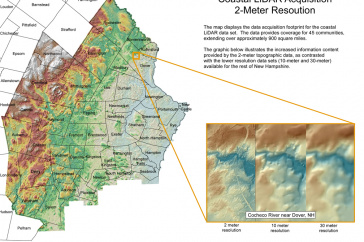
New Hampshire coastal LiDAR acquisition footprint. Download full-size photo.
DURHAM, N.H. - New high-resolution topographic data covering approximately 900 square miles of New Hampshire's coastal communities show the elevation and shape of the landscape as if stripped of all trees and buildings. The data were collected using airborne laser technology known as light detection and ranging (LiDAR) and are the result of work done by a diverse consortium of state and regional stakeholders, including the University of New Hampshire's Geographically Referenced Analysis and Information Transfer System (NH GRANIT), which is the repository of the new data and serves as the state's Geographic Information System (GIS) clearinghouse.
Researchers and planners are already using the data for a variety of projects. For example, because much of New Hampshire's Seacoast region is low elevation and susceptible to coastal flooding and sea level rise, specialists at UNH are using the LiDAR data to produce updated floodplain maps for coastal communities. UNH scientists are also using the data to model potential future inundation areas in the Lamprey River watershed based on projections of land use changes and increased precipitation.
"LiDAR technology provides a way for us to collect precise and accurate topographic data over large geographic areas and in a cost-effective manner," says GRANIT director Fay Rubin of the Earth Systems Research Center at the UNH Institute for the Study of Earth, Oceans, and Space. "The coastal data set is already being used to support our floodplain mapping and management activities and will be invaluable in a range of projects that address public safety, water resource mapping, natural resource management, and others."
The NH Geological Survey (NHGS) is using the data to develop methods of systematically mapping the location of valley walls along rivers to improve the identification of areas that are most vulnerable to flooding and erosion hazards. NHGS is also using LiDAR to enhance the delineation of surface water features, especially small headwater channels that are so important in controlling runoff during major storms.
The detailed elevation data will also support a host of other potential uses, including emergency preparedness, transportation planning, watershed protection, aerial photo processing, land cover mapping, shoreline change modeling, air mass modeling, wireless signal transmission, and mapping of relict shoreline features that record changes in sea level as the last ice sheet melted over ten thousand years ago.
LiDAR systems use thousands of pulses of red light per second from a laser mounted in a small airplane to "scan" the landscape below. Sensors detect the travel time of reflected energy from each laser pulse, and that information is used to calculate the distance from the aircraft to the ground. The collected data are processed to extract the very last pulse returns that represent the "bare earth" devoid of all features.
The data for coastal N.H. communities represent just a portion of a much larger project area encompassing approximately 9,000 square miles, extending from New York City to Eastport, Maine.
The United States Geological Survey funded the project and members of the consortium included representatives of state government, universities, local government, Indian tribes, and nonprofit organizations. All are linked by common geography, history, climate, and culture, and share a long, well-developed coastal community.
The data may be ordered from GRANIT (email granit@unh.edu for details), viewed from the GRANIT interactive data viewer (http://granitview.unh.edu), or acquired from the USGS (www.usgs.gov). Efforts are currently underway to find resources to support collection of LiDAR data for the remainder of the state.
For more information about the GRANIT program visit www.granit.unh.edu.
The University of New Hampshire, founded in 1866, is a world-class public research university with the feel of a New England liberal arts college. A land, sea, and space-grant university, UNH is the state's flagship public institution, enrolling 12,200 undergraduate and 2,300 graduate students.
-30-
Image to download: http://www.eos.unh.edu/newsimage/lidar_lg.jpg
Caption: New Hampshire coastal LiDAR acquisition footprint.
Reporters and editors: Fay Rubin is available to comment at (603) 862-4240 or mailto:fay.rubin@unh.edu"
-
Media Contact
Hachemi Aliouche | UNH Rosenberg International Franchise Center | hachemi.aliouche@unh.edu | 603-862-1884
Latest News
-
July 2, 2024
-
June 18, 2024
-
June 18, 2024
-
May 17, 2024
-
May 14, 2024