From a young age, I learned the importance of respecting the natural environment from my parents, particularly my dad, who is a restoration ecologist with the National Oceanic and Atmospheric Administration (NOAA). My experiences growing up in a family that enjoys hiking, kayaking, traveling, and other outdoor activities also contributed to my appreciation for natural resources. I took this passion for the environment and followed in my father’s footsteps by becoming an environmental conservation and sustainability major at the University of New Hampshire (UNH).
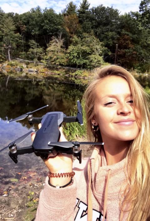
The author, Bonnie Turek, posing with a DJI drone at the Bellamy River.
At UNH, I became more intrigued by watershed management and restoration disciplines when I attended a presentation by UNH doctoral student Alexandra Evans, who was working with environmental engineering professor Dr. Kevin Gardner. Alexandra’s work focuses on the use of drones in remote sensing to study the ecological functioning and health of rivers, especially in response to dam removals. Learning about her research inspired me to pursue a Summer Undergraduate Research Fellowship (SURF) to study a local dam removal, with Dr. Gardner as my research mentor. I conducted a technical aerial drone project studying the geomorphology (natural landforms and the processes that create and change them) of the Bellamy River in Dover, New Hampshire, near an old mill that had once been powered by two dams. I investigated how to maximize the accuracy of in-stream topographic models using drone data inputs. Conducting this research and collecting this unique aerial data will contribute to the ways scientists can evaluate the effects of dam removal on natural riverine environments and inform future drone surveying projects, river restoration practices, and decision making about former mill dams present throughout New England
The two historic dams related to my project harnessed the power of the Bellamy River for the Sawyer Woolen Mills and its working sounds lulled nearby residents to sleep for many years. However, they were considered structurally deficient and “high hazards” by the New Hampshire Department of Environmental Services and were therefore targeted for removal by the end of January 2020. One of the two dams was removed in 2018, before my research began, and the second dam was scheduled for removal beginning in fall 2019, just after my summer research. The research being conducted on the removal of the Bellamy River dams aims to bring meaningful results to the scientific community and offer valuable information to local residents who may be interested or have a stake in the return of the Bellamy River to its natural, free-flowing state.
Dam Removal
Historically in the United States, we have dammed rivers for hundreds of years to provide recreational, hydropower, flood storage, and water supply benefits for many communities. In New England alone, 14,000 known dams cover the landscape due to the region’s early European settlement and history of waterpower-based industry (Magilligan et al., 2016). Large dams have completely changed the relationship of water and land and significantly altered ecosystem balance, including harmful effects on biological, chemical, and physical properties of rivers and their surrounding natural environments (Hart et al., 2002). There are risks and costs associated with the safety and maintenance of aging dams, as well as environmental and ecological concerns (FEMA, 2004). Local stakeholders and communities must address these concerns to achieve a better balance between direct human needs such as water and energy sources and sustaining healthy ecosystems that ultimately sustain us. However, whole-river ecosystem responses to dam removals are poorly understood because we have few before-and-after removal studies, even as the rate of dam removals in the United States increases (Foley et al., 2017).
Several University of New Hampshire professors and students from various disciplines participate in a New England–wide project called the Future of Dams, funded by the National Science Foundation’s Established Program to Stimulate Competitive Research program. The Future of Dams project is a stakeholder-engaged, solutions-based research initiative focused on the often complex decisions that need to be made about the future of New England dams. To add to these studies, my SURF project, coupled with Alexandra Evans’s dissertation and Future of Dams teamwork, seeks to contribute to advances in methods for aerial drone mapping and modeling, plus contribute to ecological restoration strategies, especially related to dam and other river barrier removals.
Some key physical assessments all dam removal researchers aim to address are river channel geomorphic adjustments, sediment transport, and riparian habitat changes. Traditional techniques exist for understanding these physical characteristics of rivers and streams, such as conventional surveying of river cross sections using Real Time Kinematic Global Positioning Systems and total station instruments. A total station is an electronic/optical instrument used for surveying land and is commonly used in construction. Both of these traditional surveying techniques require a team to set up and operate the equipment, collect coordinate points across a study site, and safely move the equipment through mud, sometimes fast-moving water, or other challenging terrain. These methods can be time consuming, labor intensive, and sometimes tedious, and are generally limited to small sections of a stream or river along which similar hydrologic conditions exist.
River restoration experts from across the country have voiced their interest in the alternative of using aerial drone remote sensing for ecological assessments and surveying of rivers and streams. These new drone methodologies should be affordable, repeatable, objective, and logistically feasible (Somerville & Pruitt, 2004). These are all reasons why I had such a strong interest in drone mapping for my river restoration research, and why my SURF project and similar ecological drone studies will be so significant to future restoration of natural environments.
Modeling Topography with Drones
Drone remote sensing can both develop and enhance datasets to analyze complex ecological systems that may cover a large spatial extent or are in hazardous or inaccessible areas (Turner et al., 2003). This is highly applicable to impounded waterways, which can be complex and difficult areas to access or navigate safely.
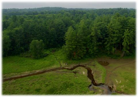
Aerial image of the Bellamy Reservoir study site captured by the author, using a drone.
Historically, remote sensing has consisted of two components: photo interpretation and photogrammetry. Photo (or image) interpretation is used to identify objects and determine their significance by using the elements of size, shape, site, shadow, color, texture, and pattern. Photogrammetry involves measurements such as scale, area, and height that can be made on the photos or images (Liverman, 1998). In simplest terms, photogrammetry is the science of making measurements from photographs (Lillesand & Kiefer, 1994). By taking photographs from at least two different perspectives and with at least 50 percent image overlap, different “lines of sight” can be developed from each exposure to points on the landscape. The results of this aerial photogrammetry include topographic maps, orthographic images (two-dimensional depictions of a three-dimensional environment), three-dimensional (3-D) models, and precise 3-D positions of points (Campbell, 1991).
Many of the maps we use today are created using photogrammetry with photographs or images taken from piloted aircraft. Drones are a remote sensing platform that can be used for photogrammetric surveys of the landscape from a close-range perspective, rather than from the more distant heights of piloted airplanes. The development of consumer-grade drones with high-resolution cameras and sensors has revolutionized our ability to assess geomorphic change in river channels and creates endless opportunities for other avenues of environmental applications.
Methods
My SURF work compared four methodologies for conducting drone surveys and involved three phases: pre-fieldwork, fieldwork, and post-fieldwork. Pre-fieldwork and post-fieldwork took up about nine weeks out of my ten-week fellowship, because I needed to learn how to properly operate surveying equipment and understand the drone surveying and photogrammetry software workflow. then needed to learn how to complete the post-processing and analysis portion of my study. Actual fieldwork took several days to complete, and drone flights took only about two hours in total.
Pre-Fieldwork: Learning to Fly—Ground School
I began by studying for the Federal Aviation Administration (FAA) Aeronautical Knowledge Test through an online lecture program. I never thought I would earn an FAA Remote Pilot License to fly drones so early in my career, but I did—and I achieved a perfect score! Next, I had to establish the specific study site in the Bellamy River reservoir over which I would fly the drone and collect imagery. My graduate student mentor suggested an area in the Bellamy Reservoir where she had previously flown her drone safely at low altitude and that she thought would be a viable study site for my project. Finally, I planned out ground control point locations across the selected study site.
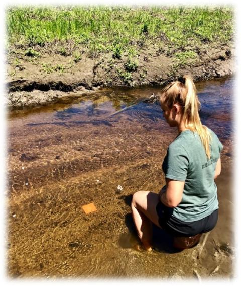
The author installing a submerged GCP marker used in the drone surveys of the Bellamy Reservoir, Dover, NH.
Ground control points, or GCPs, are marked points on the ground that have a known 3-D geographic location (defined as X, Y, Z coordinates), established by traditional surveying. The GCPs are later integrated with the images the drone collects to create a spatially accurate 2-D photomap. To conduct a highly accurate drone survey, GCPs must be evenly distributed across the study site for proper georeferencing of the drone’s data. I planned the location of fifteen GCPs to be submerged in the wetted channel areas and another fifteen GCPs in terrestrial locations. After completing a map of GCP locations, I purchased the necessary materials to create GCP markers: steel rebar to be inserted into the sediment, with bright orange caps for the tops of the rebar so that the GCPs would be visible in drone images.
Next, I created several automated drone flight plans on DJI Flight Planner software to ensure total coverage of the study site, with sufficient image overlap and flight path safety precautions. With my drone pilot license in hand, GCP materials organized, flight paths ready to go, and drone and surveying equipment fully charged, I was ready to conduct my fieldwork.
Fieldwork: Taking Flight!
Once at the field site in Dover, New Hampshire, I suited up in waders and, with help from my research team, set up the GCP markers based on the map I had created. Installation of these GCP markers involved navigating the stream site in various water depths (up to four feet deep), hammering steel rebar into the soil, and placing the orange rebar caps on top. Then, I needed to identify the exact locations of the GCPs (submerged and terrestrial) using conventional surveying methods. I set up the total station surveying base on a geo-referenced benchmark point in the middle of the reservoir. This benchmark point is of known geographic location from previous surveying studies by UNH researchers or other professionals and allows us to calculate the geographic coordinates and elevations of other points—in this case, the GCPs I had placed—in the surrounding study site.
In addition to the GCP locations, I surveyed approximately 100 checkpoints throughout the study site. Unlike the GCPs, these checkpoints are not marked in the landscape but can be aligned through a geodetic datum (a standardized coordinate system and a set of reference points used for locating places on the Earth's surface) to compare with coordinates used in drone-based models. These checkpoints are important for drone model accuracy assessments later on in the study.
I conducted drone flights immediately after conventionally surveying the GCPs to ensure there was no major disruption of the physical riverine environment between surveying and the flights. I used a DJI Phantom 3 Professional model drone, purchased through the Future of Dams research grant and maintained and operated mainly by PhD student Alexandra Evans. With my iPhone and flight-planner application linked to the drone controller, I uploaded each flight mission which I had prepared and completed four flights total. These included two nadir flight paths (with the drone camera facing straight down toward the ground at –90 degrees) and two angled flight paths (with the drone camera at a –70 degree angle).
The drone connects wirelessly to a handheld controller, which has two control rods to maneuver the drone up, down, left, right, forward, and back. However, during automated flight paths, the drone does most of the work; you just have to watch out for any flight hazards such as birds or planes. My iPhone displayed a livestream video during the flight. I had practiced using the equipment and flying the drone on the UNH campus several times, but it was much cooler flying over a beautiful riverscape and seeing the wonderful images it collected along the way, all for my own research project. After completing all surveying and drone flights, I was ready to process the imagery I had collected of the study site.
Post-Fieldwork: Coming In for Landing
To begin post-fieldwork I downloaded the imagery from the drone’s micro SD card onto the lab computer. Next, I downloaded the survey data from the total station’s Bluetooth receiver to be processed and used in creating the georeferenced drone models. Then I began the Agisoft PhotoScan drone photogrammetry software workflow, which would help me create meaningful topographic maps from the drone images.
Initial steps of this workflow involved uploading the images to the software and checking image quality, aligning images, and building a “cloud” of overlapping image pairs in space. I then manually entered the conventionally surveyed GCP coordinates and elevations to georeference the model. This step was critical to my study. To investigate how to maximize the accuracy of drone mapping, I tested four different configurations of GCPs used in the software to create four different sets of models: fifteen submerged GCPs, fifteen terrestrial GCPs, fifteen mixed GCPs (submerged and terrestrial), and thirty mixed GCPs.
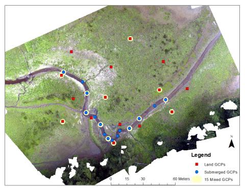
Figure 1: Orthomosaic (2-D) map product from aerial imagery displaying GCP configurations used at study site.
From each of the four configurations of GCPs, the software is used to re-create the existing structures and 3-D landscape captured by the drone camera by building a denser cloud of matching points. Finally, the software built 2-D photomaps (orthomosaics) and digital elevation models (DEMs) from the resulting 3-D drone models (see Figure 1).
The PhotoScan software generated a general accuracy report for each of the four drone model iterations. However, I performed an additional accuracy assessment of each model in a separate GIS software by comparing the drone’s digital elevation model with a layer of the conventionally surveyed checkpoints we had also collected at the study site. These checkpoints are separate from the GCP locations and are not used to construct the drone models—only to assess their accuracy. I reported these results in graphs and figures to convey the varying precision of each GCP configuration used in an in-stream topography drone survey.
Contributions and Challenges
The drone surveys I performed yielded topographic models with anticipated levels of accuracy, with a low-average range of error estimated using the GCPs from 1.5 cm to 6 cm (compared with the conventional survey for GCPs). The greatest drone mapping inaccuracies were found in elevation measurements, especially in deep submerged areas and sparsely vegetated terrestrial areas (Figure 2). Through my results, I found that although including submerged GCPs in drone workflows enhances modeling of the submerged topography, there is compromise in the mapping accuracy of surrounding terrestrial areas (Figure 3).
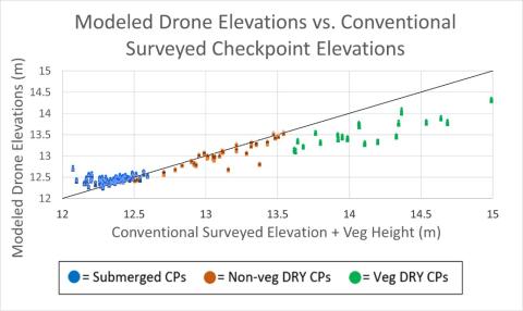
Figure 2. Comparison of modeled drone elevations versus conventionally surveyed checkpoints at each tested point across study site. (1:1 line used as comparison). Dry, vegetated checkpoints of higher elevations (e.g., reeds) are underestimated by the drone, whereas submerged aquatic points are overestimated.
My project supplements findings from previous studies identifying fifteen as the most efficient number of GCPs to georeference in drone survey workflows (Agüerra-Vega et al., 2017). Agüerra-Vega et al. found that using thirty GCPs to georeference yielded only marginally higher drone model accuracies than using fifteen. However, results from my study demonstrated that using thirty GCPs resulted in a slightly less accurate model. Overall, my results suggest that GCPs should be placed in areas of highest importance to the particular project for optimal drone mapping accuracy. For example, if researchers are concerned with how a river channel bed might change after dam removal, they should place GCP markers in the submerged environment; however, if researchers are interested in the alteration of the terrestrial banks of the stream, they should place GCPs in dry land locations.
Factors contributing to drone error in modeling submerged river areas include high water turbidity levels, light reflectance, daylight conditions, and water turbulence or surface turbulence, which must all be further explored. It’s also important to note that when light travels from air into water, it slows down, causing it to change direction
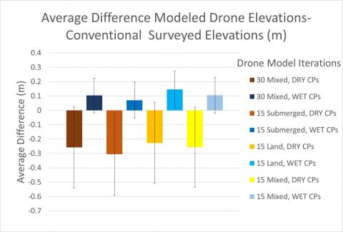
Figure 3. Average difference of modeled drone elevations to conventional survey elevations. Fifteen submerged GCP configuration results in highest accuracy of submerged mapping.
slightly. This change of direction is called refraction, and therefore a water refraction correction needs to be applied to the drone elevation models to adjust for the drone’s overestimation of submerged area elevations (Dietrich, 2017). In sum, I found that drones are a highly valuable tool for efficient and accurate photogrammetric mapping of riverscapes, as well as for capturing important features of the landscape from a unique aerial perspective.
The Sky’s the Limit
My SURF project and my findings contribute important information to the broader field of ecological monitoring and restoration planning. The results of this study will help collaborative researchers who use similar methods refine their procedures and supplement traditional fieldwork sampling and surveying methods. With higher accuracy subsurface elevation modeling and high overall digital elevation model accuracy, these drone photogrammetric techniques will improve assessments of ecosystems and public infrastructure like dams, before-and-after management activities, and disturbance events such as natural disasters.
In the fall of 2019, I performed historical examinations and literature reviews on the social aspects of using drone technology in environmental planning, which continued and supplemented my SURF project and fulfilled my senior capstone thesis. I learned that the benefits that drones offer the fields of environmental monitoring and conservation are being realized by an ever-increasing number of researchers, students, and environmental engineers and scientists. Drones not only are valuable tools in river restoration projects but also contribute to diverse sustainability assessments and can provide great insight into the environmental, economic, and social impacts of projects.
Along with my SURF project’s significant contribution to the broader field of study, it helped me find a niche and a passion in the environmental field. I remain motivated by seeing the wonderful possibilities of ecological monitoring and environmental restoration that can be achieved by using drone technology.
My project analysis enhanced my technical and analytical skills in using high-tech surveying methods, GIS, and remote sensing software. Mastering these skills added to my qualifications for academic and career advancement and sparked my pursuit of forthcoming studies in graduate school. I will be able to use this experience as a foundation for additional studies, research, or professional positions in the discipline, ultimately leading to a satisfying career that involves monitoring ecosystems and landscape environments, land use changes, and restoration planning through combined traditional fieldwork and remote sensing techniques. Without hesitation, I look forward to a new challenge in a master’s program in environmental science, continuing in my father’s footsteps in the ecological restoration field, and developing and completing my own challenging remote sensing research project in conjunction with an experienced mentor at a new academic institution beginning in fall 2020.
Completing my SURF project would not have been possible without the network of wonderful people who supported me throughout the entire process. First, I’d like to thank my mentor, Dr. Kevin Gardner, whose leadership and guidance has supported and encouraged me throughout my research project. I am also extremely grateful for his continued support throughout my pursuit of conducting similar academic research through graduate programs and his writing of recommendation letters on my behalf. Special thanks to UNH PhD student Alexandra Evans and Mr. Scott Greenwood for their mentorship, continuous hands-on assistance, and contributions they provided throughout this research and learning experience. I’d also like to thank undergraduate student Peyton Sanborn for her hard work in and out of the field to collaboratively complete surveying tasks and create valuable drone model products. Last, I want to thank the Hamel Center for Undergraduate Research and my donors, Mr. Dana Hamel and the J. Raymond Hepler Endowed Fund. I am very appreciative of all who played a role in making this project possible and highly rewarding.
References
Agüera-Vega, F., Carvajal-Ramírez, F., and Martínez-Carricondo, P. (2017). Assessment of photogrammetric mapping accuracy based on variation ground control points number using unmanned aerial vehicle. Measurement, 98, 221–227. doi.org/10.1016/j.measurement.2016.12.002.
Campbell, J. B. (1991). “Introduction to Remotely Sensed Data.” ISPRS Journal of Photogrammetry and Remote Sensing, 46(1), 48–49. doi:10.1016/0924-2716(91)90006-h.
Dietrich, J. (2017). Bathymetric Structure from Motion: Extracting shallow stream bathymetry from multi-view stereo photogrammetry. Earth Surface Processes and Landforms, 42, 355–364. doi: 10.1002/esp.4060.
Federal Emergency Management Agency (FEMA). (2004). National Dam Safety Program—25 Years of Excellence. Washington DC: Federal Emergency Management Agency.
Foley, M. M., Magilligan, F. J., Torgersen, C. E., Major, J. J., Anderson, C. W., Connolly, P. J., et al. (2017). Landscape context and the biophysical response of rivers to dam removal in the United States. PLoS One, 12(7), e0180107.
Hart, D. D., Johnson, T. E., Bushaw-Newton, K. L., Horwitz, R. J., Bednarek, A. T., Charles, D. F., & Velinsky, D. J. (2002). Dam removal: Challenges and opportunities for ecological research and river restoration. AIBS Bulletin, 52(8), 669–682.
Lillesand, T. M., & R. W. Kiefer. (1994). Remote sensing and image interpretation (third edition). John Wiley & Sons.
Liverman, Diana. (1998). People and pixels: Linking remote sensing and social science. National Academy Press.
Magilligan, F. J., Graber, B. E., Nislow, K. H., Chipman, J. W., Sneddon, C. S., & Fox, C. A. (2016). River restoration by dam removal: Enhancing connectivity at watershed scales. Elementa: Science of the Anthropocene, 4, 000108. doi:10.12952/journal.elementa.000108.
Somerville, D. E., & Pruitt, B. A. (2004). Physical stream assessment: A review of selected protocols for use in the Clean Water Act Section 404 Program. Prepared for the US Environmental Protection Agency, Office of Wetlands, Oceans, and Watersheds, Wetlands Division (Order No. 3W-0503-NATX), Washington, DC.
Turner, W., Spector, S., Gardiner, N., Fladeland, M., Sterling, E., & Steininger, M. (2003). Remote sensing for biodiversity science and conservation. Trends in Ecology & Evolution, 18, 306–314.
Author and Mentor Bios
Bonnie Turek, from Richmond, Rhode Island, came to the University of New Hampshire (UNH) to pursue a bachelor of science degree in environmental conservation and sustainability with minors in environmental resource economics and geospatial analysis. During her junior year, Bonnie attended a presentation by PhD student Alexandra Evans about using drones for research and was so intrigued that she reached out to find out how she could get involved. She completed her research through the Summer Undergraduate Research Fellowship (SURF) program in 2019. In the process, Bonnie earned her remote pilot license and says that flying drones was a lot of fun, but sometimes nerve-racking. She heard about Inquiry during her SURF experience and was encouraged to submit her research by her graduate student mentor. In the fall of 2020, Bonnie will begin graduate studies, with the ultimate career goal of a position in the field of natural resource sciences or resource management that will allow her to use both traditional fieldwork and geospatial/remote-sensing skills.
Kevin Gardner worked at the University of New Hampshire (UNH) from 1999 to 2019 before moving to work at the University of Louisville. His research focuses on mitigating human impact on the environment. This involves the disciplines of sustainability science and engineering to approach the overlap of social, ecological, and technological problems, such as dam removals and analyzing the dangers of PFAS/PFOA compounds present in soils and groundwater. In his twenty years at UNH, Dr. Gardner mentored a few dozen undergraduate researchers; he believes that mentoring eager, responsive, and engaged people makes for a fun, interesting, and satisfying experience. He thinks that learning to write for Inquiry’s broader audience is incredibly useful for students in his discipline. Because Inquiry interfaces with members of the public who come from diverse backgrounds, he says, it is critical to recognize your audience and to speak and write appropriately.
Copyright 2020, Bonnie Turek
